 Reinhard WimmerCruise DirectorEntertainer
The cataract stretch
Iron Gates
One of Europe’s most impressive river passages on the border between Serbia and Romania.
Iron Gates
The Iron Gates are a gorge on the Danube. They lie in the southern Carpathians, between the Serbian Carpathians and the Banat Mountains, on the border between Serbia and Romania.
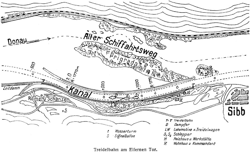
Until the hazards were reduced in 1972 in connection with the Iron Gate I power station, this was considered the most dangerous stretch of the Danube for navigation and could not be passed without local pilots. For decades, locomotives towed ships upstream. The cataract stretch is one of Europe’s most impressive river gorges. At the Kazan Gorge between Orșova and Donji Milanovac, the Danube narrows to 160 metres. Because of the steep sides of the gorge, parts of today’s reservoir are not much wider than the natural riverbed despite the rise in water level.
Protected areas were established on both sides of the Danube: the Djerdap National Park in Serbia and the Iron Gates Natural Park in Romania. Besides Orșova, nearby towns include Moldova Nouă and Drobeta-Turnu Severin in Romania, where a museum tells the story of the Porțile de Fier power station, and Golubac with its fortress on the banks of the Danube.
In 2005, Serbian archaeologists discovered the remains of a settlement around 9,000 years old in the east of the country. The site is in an inaccessible cave above the Danube. Excavations have revealed fireplaces and flat stones used as anvils, as well as numerous fish and other animal bones. The site is near Lepenski Vir, a Mesolithic site where a settlement more than 8,500 years old, with burial places and elaborate sculptures, was discovered in the 1960s.
Roman structures
A well-known Roman monument is the Tabula Traiana, carved into the rock at the Iron Gates on the Serbian side of the Danube.
This is a tablet installed by the Roman emperor Trajan in the year 100 to commemorate completion of the road along the right bank in the lower Danube gorge. Floating dolphins are depicted on both sides, an eagle with spread wings appears above, and three six-petalled roses on each side are carved into the rock in relief.
During construction of the power station, the tablet was moved to a higher location to preserve it from the rising water level. Since then, it has only been visible from the water.
A 3.2 km lock canal built by the Romans along the right bank to bypass the Prigrada rock barrier in the riverbed is now submerged and no longer visible.
Between 102 and 105, the important Roman architect Apollodorus of Damascus built Trajan’s Bridge a little farther downstream near present-day Drobeta-Turnu Severin, extending a strategically important Roman road across what was then the border river.
The bridge, the longest in the ancient world, was soon used for the invasion of Dacia in the Second Dacian War of 105/106. With the incorporation of Dacia as a Roman province, the frontier of the Roman Empire moved beyond the Danube.
During river regulation works in the 19th century, substantial volumes of rock were removed from these rock shelves through underwater blasting or targeted quarrying, with temporary dams exposing the rock. Construction of these protective dams also created a large short-term demand for broken stone, met by opening new quarries on the Serbian bank.
In addition to these works, dams parallel to the banks narrowed the river’s cross-section at certain points to maintain a water depth suitable for shipping.
The most dangerous area for earlier shipping begins downstream near the now-submerged island of Ada Kaleh, with a narrow limestone band extending at a shallow angle from the Romanian bank towards the western bank in Serbia.
Farther downstream, increasingly wide parallel rock shelves of heavily folded clay slate and calcareous slate give way to limestone containing mica and quartz fragments: the PRIGRADA BANK.
The PRIGRADA rock shelf extends for about 3 kilometres from bank to bank across the river valley and forms the actual Iron Gates.
A little below these rock barriers, metamorphic crystalline rocks cross the riverbed. Their highest sections once formed further dangerous rock groups known as the Little Iron Gates. These groups consist of biotite-bearing quartzites and mica schist (fine-grained granite), which could protrude above the Danube depending on the seasonal water level.